The Best Day Hike Out of Fresno, CA
Fresno gets a lot of abuse and derision and, to be honest, in my humble opinion at least, some of that is well deserved. The city’s air has been rated as among the worst in the country by the AmericanLung Association, close to 1 in 4 (23%) of its residents live in poverty, and it ranks near the bottom of the heap among larger cities with respect to percapita spending on parks and recreation. And don’t even get me started on the dearth of intellectual and cultural life in Fresno.
Fortunately
for Fresno, these drawbacks are to some degree offset by its one major plus,
namely close proximity to what many argue is the finest mountain scenery in
America. I’m talking about the so-called
“High Sierra,” which comprises the tallest and most rugged part of the Sierra
Nevada Mountain Range. The latter
stretches from the Kern River Plateau to the south to the North Fork of the
Feather River to the north. The south
end of the “High Sierra” begins at the south boundary of Sequoia National Park
and ends at the north boundary of Yosemite National Park. The “High Sierra” is home to a vast number of
pristine lakes, most of which are at or above the timber line and lovely
subalpine and alpine meadows, all of which are set against the backdrop of high
jagged peaks. All but two of
California’s 15 14,000+ feet peaks are here, with scores of other mountains
topping out at between 11,000 to 14,000 feet.
Three of
America’s premier mountain national parks, Sequoia, Kings Canyon, and Yosemite,
are in the “High Sierra,” and all three are within easy driving distance of
Fresno. Yosemite Valley is around 90
minutes down the road on State Route 41, while the west entrances for Kings
Canyon and Sequoia National Parks are both a little over an hour by car from
Fresno. Trailheads for exploring the
John Muir and Ansel Adams Wildernesses between Kings Canyon and Yosemite are 2-3
hours by car via the roads up to Wishon and Courtright Reservoirs above Shaver
Lake, Granite Creek, which is east of Mammoth Pool, and Florence and Edison Lakes
(these last two and Shaver Lake are also reservoirs). Only two other cities in America, Denver and
Seattle, have such an abundance of beautiful mountains in their backyards.
The only
problem with Fresno’s location is that getting to the Sierra Crest to bag the really
high summits takes a bit more time and effort.
In the case of Yosemite National Park, one has to drive beyond the
Valley on State Route 120 to May Lake and Tuolumne Meadows, which adds another
1-2 hours to one’s Yosemite driving time.
This makes it somewhat difficult to bag peaks in these places as day
hikes from Fresno. In the case of the
trailheads into the John Muir and Ansel Adams Wildernesses mentioned above,
getting to the high peaks involves at least a day’s worth of backpacking. I could add here that the final drive into
Edison and Florence Lakes over Kaiser Pass goes over a very sketchy one a half
lane gravel road. In the other two
national parks near Fresno, Kings Canyon and Sequoia, it not only takes at
least a day of backpacking to come into close proximity to the High Sierra alpine
scenery, but the trailheads there start at very low elevations. The one at the end of State Route 180 in
Kings Canyon is just 4,600 feet. Years
ago, when I was in my early 40s, I did the 5,400-foot climb from there over
Avalanche Pass on the first day of a 100+ mile loop trip carrying a heavy
backpack and it damned near wasted me.
The good
news for Fresno peak baggers is that there is one major exception to this
picture. That exception is the
10,320-foot Kaiser Peak on the north side of Huntington Lake. Despite all my years of living in Fresno and
enjoying the Sierra Nevada Mountains, Kaiser Peak had been, for whatever
reason, off my radar screen. I wasn’t
even aware of this hike until reading about it in the 101 HIKES IN NORTHERN
CALIFORNIA hiking guide book (it’s chock full of really good day hikes). After doing that, I jumped at the chance to
bag this particular peak last summer, figuring it would help get me in
condition to climb up the volcanoes in Lassen National Park. That hiking activity is described in my
previous mountain climbing post.
To get to
the Kaiser Peak trailhead, I drove north out of Fresno on Friant Road to
Millerton Lake and Friant Dam, turning left and heading south down Lake
Millerton Road, past the Brighton Crest gated community and golf course and
Table Mountain Casino to where it forms a “T” junction with Auberry Road. There I turned left (east) and drove through
the tiny hamlet of Prather. After
passing through it, a sign directed me to the junction of California State
Route 168. That road climbs up Pine
Ridge and goes past Shaver Lake—the reservoir and so-named little town— and the
entrance to the China Peak Ski Resort before reaching the east shore of
Huntington Lake (another reservoir).
Highway 168 ends here at a “T” junction.
A right turn at this junction takes one up that sketchy road to Florence
and Edison Lakes. I turned left, driving
a bit along the north side of Huntington before taking the narrow road to the D
& F Packing Station. I parked my car
in one of the small number of spaces for day hiker parking just outside the
station.
I walked
through the packing station to get to the trailhead for my 10-mile roundtrip
hike to Kaiser Peak. There two trails
split off, and I chose the left one to Kaiser Peak. I ascended up to another junction, going
straight ahead before paralleling Deer Creek, where the real climbing fun
began. The next couple of miles was a
relentless slog up numerous switchbacks on the forested ridge bordering the
north shore of Huntington Lake. While
pausing to rest and catch my breath, I took in some nice views of the lake—by
that time I was well above it. The other
main highlight of this stretch of the trail was the massive and oddly shaped
College Rock (how did it get that name, was it a summer hangout for college
students at one time?). The trail
leveled off a bit making a more gradual climb, passing through a meadow, before
hitting a steep climb up a narrow chute.
After I got
up that chute, the barren alpine landscape of Kaiser Ridge exploded into
view. I noticed a peak off to the right
(north) and, mistakenly believing it was Kaiser, headed up it through the brush
and talus. This likely added at least a
couple feet to the 3,000+ feet of climbing I did to get up to Kaiser Peak. A shot I did of that false summit is shown
below:

I should
have stayed on the trail, which is on the left side of the above photo. In any case, after reaching the top of the
false summit, I could see lots of people following that trail up to the real
Kaiser Peak. That trail climbs some before
rounding the east and south base of Kaiser Peak’s knoll-like flat top. The final ascent of the Kaiser Peak summit
from part of the trail was a simple 100-foot class 1 walkup.
Unlike most
of the mountains along the High Sierra crest, which are scrunched together with
other tall summits, Kaiser Peak is all by its lonesome at the end of Kaiser
Ridge, which extends west from Kaiser Pass.
The peak therefore has a lot of prominence, which makes for sweeping and
spectacular vistas from its top. After
finishing the climb, I thought to myself, “What took you so long to haul your
ass up here?” Reflecting a bit further,
I thought, “Well, better late than never!”
Such was certainly the case with Kaiser Peak.
Looking to
the south and west, I could get Huntington Lake into a single frame in my
camera. Beyond the lake, I saw the
smoggy haze that blankets the San Joaquin Valley most summer days and was
reminded about why it is rated one of the worst air basins in the country.
Turning more to the southeast, the high peaks of the Sierra Nevada’s massive, rugged eastern crest came into view.

As my gaze
to the east shifted more to the north, one the High Sierra’s mini-mountain
ranges, the Silver Divide, came into view.
I’m not quite sure about the name of the tallest peak in the photo off
to the right.

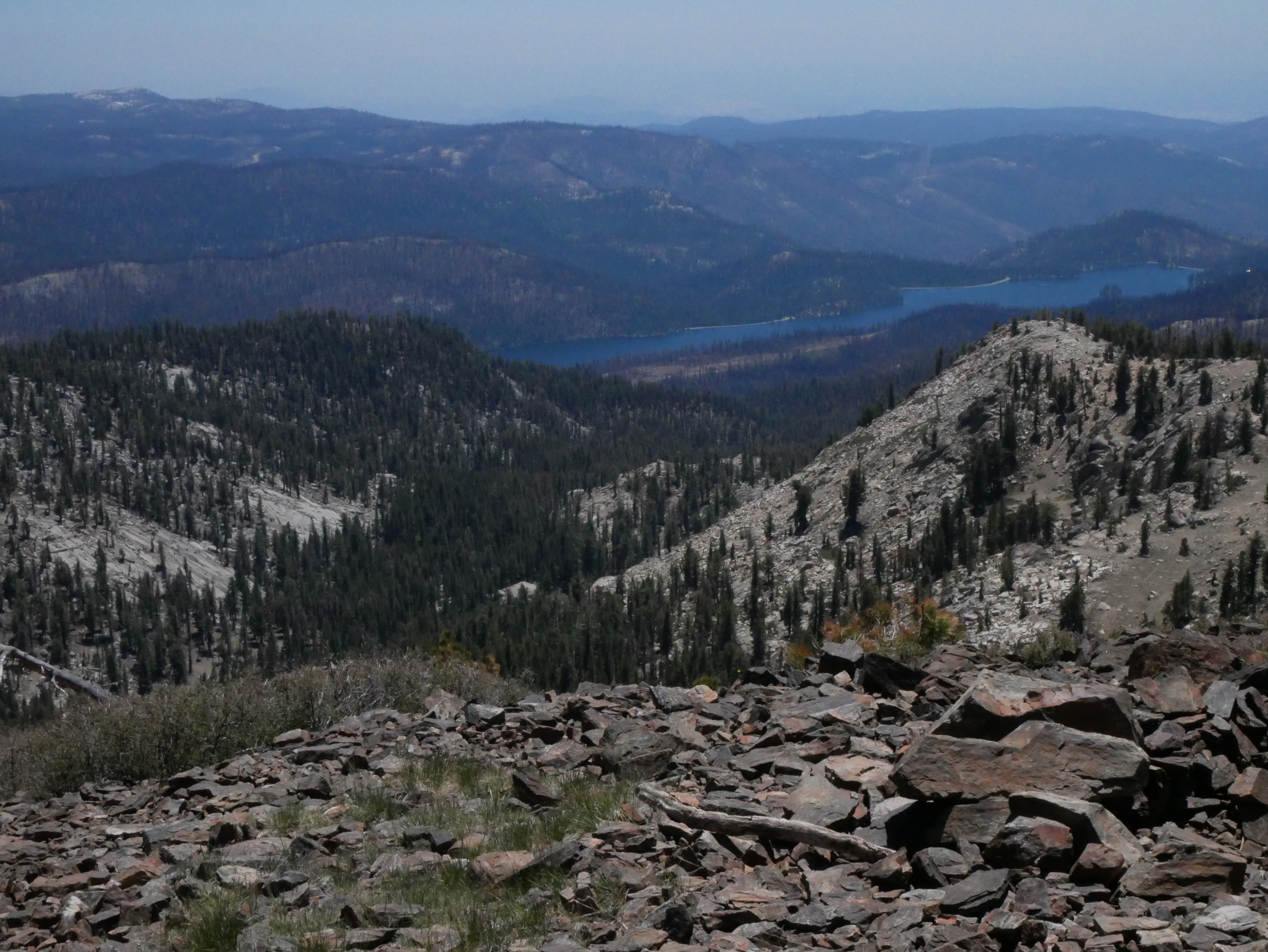
Looking in this general direction, I also got a glimpse of either Florence or Edison Lake (see the left side of the photo below).

Last but certainly least, I had stunning views looking north and west from the Kaiser Peak summit.


Getting back down the mountain was easier than climbing it, but
was still no picnic. Doing the
3,000-foot drop over 5 miles back to my car did a number of my aged pair of
legs. Indeed, toward the end of that
trek, I could barely walk and felt an enormous sight relief while staggering
back to my car. That said, doing this
hike certainly was a good way to get into condition for the subsequent climbs
up Lassen National Volcanic Park’s volcanoes I did later that summer.
I was also fortunate to have done this particular day hike
on July 2nd. A few days after
I hiked up Kaiser Peak, the Washburn fire near the Mariposa Grove in Yosemite
National Park broke out. It quickly
engulfed a large area in and outside of the park, throwing up massive amounts
of smoke. I went up to Courtright Reservoir
shortly after Washburn fire had started and everything was hazy and smoky; it
was hard to see even the lake from an adjacent ridge.
One final note about this hike. Save for the initial stretch along Deer Creek,
there is no trailside water on this hike.
So bring lots of water!
Now for a for a few words about Shaver Lake, the main town
on the way up to the Kaiser Peak trailhead.
For hungry Kaiser Peak hikers wishing to get a bite in Shaver Lake after
bagging the Kaiser summit, I can heartily recommend one dining establishment,
the Hungry Hut, in the middle of the main 168 drag running through the
town. This place literally is a hut and
serves up very good sandwiches and burgers paired with pencil thin fries that
are out of this world. While you’re in
this neck of the woods, also check out the Central Sierra Museum. It’s on the north side of the town and to get
there, take the turnout and road to Camp Edison. This place has numerous interesting and
informative exhibits and artifacts, and visitors to it will learn a thing or
two about the rich history of this part of the Sierra Nevada.
That’s it
for now, until this Mountain Man’s next hiking adventure story. In the meantime, get up to the mountains and
go hiking somewhere. Take my word, doing
that is extremely therapeutic and will really help center you psychologically!!


Comments
Post a Comment